

Katam Technologies AB software
Katam - Reports and Tools for Precision Forestry Software
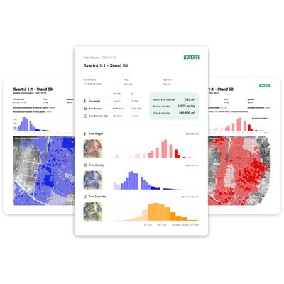
Katam reports give you a detailed and convenient overview of tree heights, diameters and density in any stand. Capture video of the stand with a drone or smartphone and upload it to Katam for processing. You will get downloadable reports within minutes. Katam brings the power and speed of digitalisation to your forestry business. Analyse tree density, height and diameter in any part of your stands. Use a drone or smartphone app to collect image data. Katam will generate the reports you need, right when you need them.
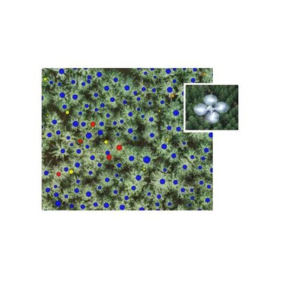
Katam TreeMap - Capture Images with a Drone
By capturing images with a drone, you can create an analysis of the entire stand while still working in the field. The KATAM TreeMap solution shows variations wthin a forest stand with distribution of tree density and height over all parts of the stand.
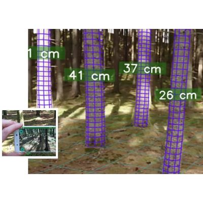
Katam - Smartphone Scans Software
By capturing video with the KATAM Forest app, you can create a report that covers tree diameter and density of a scanned area directly in your smartphone. The app replaces traditional analog measuring tools.
Katam TreeMap - Precise Route Planning Tool
Optimise instructions for thinning strength and route planning in advance with more precise data. With Katam, you are always prepared to adapt to local variations in the total stand.