

Soft.Farm software
Soft.Farm - Crop Monitoring Services
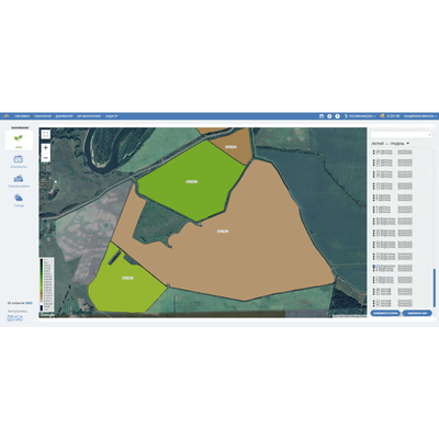
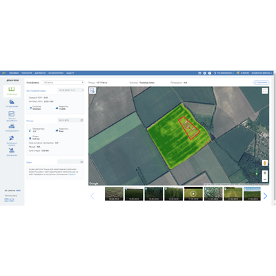
The satellite monitoring and assessment of the vegetation index NDVI (Normalized Difference Vegetation Index) will help to timely identify the fields on which crops are developing poorly, and to take corresponding management decisions. In spring, the agronomist main problem is: “How did winter wheat survive winter?” It’s still impossible to drive to the fields, but the work need to be planned based on the current state of the crop. An indispensable tool for solving this problem is satellite monitoring of the NDVI index in the Soft.Farm system. The satellite images reflect the distribution of vegetative mass across the field, which makes it possible to identify the areas with low vegetation and to develop agrotechnical measures to improve them. Analyzing the NDVI index by year will help to determine the productive and unproductive fields and this information will help to form a crop rotation optimally. For example, an analysis of the NDVI index will reveal fields in which there has never been a high yield for five years, and you can decide whether to invest in fertilizer or to sow perennial grasses for feed. Start using satellite monitoring of crops and the NDVI index to increase profits from agricultural activity.
Soft.Farm - Soil Properties Software
The main asset of an agricultural enterprise is a soil. Growing a good harvest requires careful study of the composition of the soil on the basis of which the crops are grown. Soil assessment begins with the determination of the agrophysical and agrochemical properties of the soil. It is very expensive and not always effective to carry out chemical analysis of the soil of the entire land bank using 3-5 ha scale; it is more expedient to analyze the NDVI index over several years, to identify problem areas of the field and then to examine them carefully. The obtained results of the chemical analysis or measurement of soil compaction (using a penetrometer) can be downloaded to the Cartograms module of the Soft.Farm system, which will build a map of the indicators distribution across the field, from one soil sample to another. Thus, you will be able to determine the properties of the soil at any point of the field, which is much more profitable than a net survey. It is no longer a problem to store and search of information upon the nutrient content (N P K and others), mechanical composition or soil moisture as the access to information will be fast, convenient and safe.