

Veris Technologies, Inc. products
Real-time Sensor Platforms
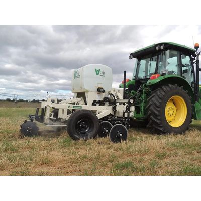
Veris - Model MSP3 - Tractor Series - Soil Scanner
The Veris MSP3 soil scanner is a unique sensor platform capable of mapping three crucial soil characteristics in a single pass. While driving at about 5 to 8 miles/hour, the system measures soil pH, the organic matter/carbon percentage and the EC (soil type) throughout the rooting depth with a 1ft and 3ft measurement.
Agronomic Sensors
Veris - Model EC 3100 - On-The-Go Precision Agriculture Soil Mapping
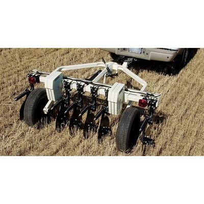
This is the model that launched on-the-go soil mapping. With its dual-depth arrays and rugged reliability, it has become the standard for commercial EC mappers around the world. From the welded tubular steel framework of the implement to the six heavy-duty coulter-electrodes, it’s readily apparent this machine is built for hard-nosed fieldwork. And what isn’t visible is even more impressive—proven electrical arrays that are free from metal interference, along with data recording that produces the most accurate soil EC information. It easily handles tilled or untilled fields—and when it comes time to head to the next field, trailer-type hub assemblies allow it to be towed at highway speeds.
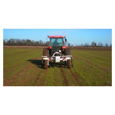
Veris - Model EC 3150 - Agronomic Mobile Sensor Platform (MSP)
The Veris 3150 has many of the proven features of the 3100, but is built on the Mobile Sensor Platform (MSP). This means other sensor modules—such as pH or optical, can be added to the platform. Customers who envision mapping with those sensors in the future can get started using the MSP with EC 3150. The MSP provides additional flexibility: it can be used in a pull-type or 3-point hitch configuration. Its coulter-electrodes can be moved and wings extended to allow mapping in emerged row crops—or wings removed for vineyard or other narrow applications. Yet it has the rugged welded steel framework, heavy-duty coulter-electrodes, dual depth arrays, and user simplicity that has made Veris EC systems the worldwide leader in on-the-go soil sensing.
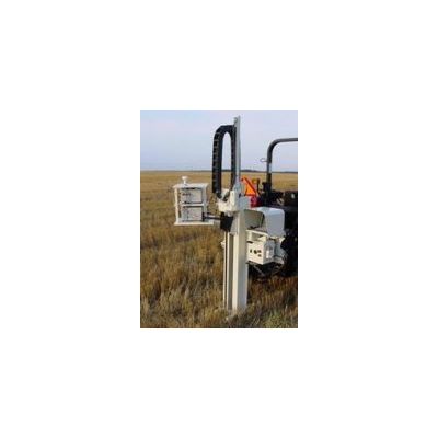
Veris - Model P4000 - Soil Core Hydraulic Probes
Whether you’re collecting soil cores, measuring compaction, or characterizing soil profiles—the Veris line of hydraulic probes has the technology to meet your needs. The Veris 4-Sensor probe acquires spectral measurements in the visible and near-infrared range, along with soil EC and insertion force sensing. It uses the same software and spectrometers as the Veris VIS-NIR Shank system--extending the capability of VIS-NIR technology into the soil profile. Choose either a tractor-mounted or truck-bed skid mount. Both feature 54” (137 cm) stroke cylinders, hydraulic side-shift, convenient controls, and heavy-duty construction.
The Soil
Veris - Model Soil EC - Soil Electrical Conductivity Measurement
Mapping texture with Soil EC captures this key physical property. Soil EC is soil electrical conductivity – a measurement of how much electrical current soil can conduct. It’s an effective way to map soil texture because smaller soil particles such as clay conduct more current than larger silt and sand particles. Growers, consultants, and suppliers are Veris soil EC mapping to devise management zones, set soil sampling locations, create variable rate seeding prescriptions, better manage nitrogen applications, and improve irrigation prescriptions - just to name a few uses of Veris EC maps.
Veris - Model Soil OM - Soil Organic Matter
An indicator of past productivity and a driver of future yields. If you want to vary inputs based on productive capacity, a precise map of organic matter is crucial. Because organic matter forms slowly over time, the soils that are higher in organic matter possess the combination of soil texture, internal drainage, landscape position, and other factors that over long periods of time have consistently generated additional plant growth - resulting in higher OM. Now, that increased OM level also leads to even higher productive capacity - due to better water and nutrient - holding ability, nitrogen mineralization and soil structure. Most precision agriculture applications can be improved with an accurate OM map layer - variable rate population, nitrogen management, sampling zones, soil amendments, herbicides, cultivar selection, and more.
Veris - High Resolution Soil pH Maps
High resolution pH maps improve management of this key soil property. Soil pH is an important factor in crop production. Nutrient usage, crop growth, and herbicide activity are all affected by the pH of the soil. Grid samples are simply not dense enough to do the job. Within many 2.5 acre (1ha) grids, there is a wide range of pH values, often ranging from soils that call for lime to soils that are already extremely high in pH.