

agriCAD - S.C.S. Survey Cad System Srl
- Home
- Companies
- agriCAD - S.C.S. Survey Cad System Srl
- Products
- agriCAD - Model K300 - Professional GPS ...


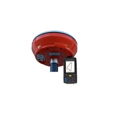
agriCAD - Model K300 -Professional GPS System
K300 is a professional GPS sistem indicated for measurement of large plots , for cartography, for GIS requiring sub-meter accuracy. K300 sistem is ideal for walking measures, or by mounting the receiver on a magnetic base fixed on the roof of your vehicle.
- With receiver mounted on a pole 2.5m;
- With receiver mounted on magnetic to be fixed on roof of the car.
- Frequency: mono frequency(L1)
- Channel: 120
- Satellites: the receivers are double-constellation, GPS + GLONASS
- Antenna: internal, micro-centered with high precision, filtered to avoid electromagnetic and radiofrequency disturbances
- Precision: sub-metric, 50cm (in DGPS mode with SBAS satellites)
- Comunicazione: Bluetooth up to 10 meters
- Battery: Litio, 12 hours(rover)