

Model IASMHYN -Improved Management of Agricultural Systems By Monitoring And Hydrological Evaluation
The tool has been cross-validated with estimates of evapotranspiration and soil water content in agricultural sites in South Tyrol (Italy) in the framework of MONALISA project. A comparison with physical based models, satellite imagery and radar data will allow further generalization of the product.
The ultimate goal of the tool is to make available on the market a service that is generally applicable in Europe, using commonly available data, to provide single farmers and organizations effective and up to date information for planning and programming their activities.
- Automatic acquisition of observed data, both from ground stations and remote sensing, concerning precipitation (RADAR) and temperature (MODIS-LST) available from various sources;
- Interpolation of acquisitions through regression kriging in order to spatially map the meteorological data;
- Run of hydrological models to obtain spatial information of hydrological soil variables of immediate interest in agriculture.
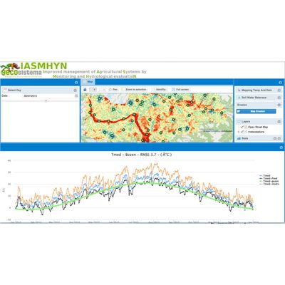
The real time results that are produced are available through a web interface and provide the user with spatial maps and time series of the following variables, supporting decision on irrigation, soil protection from erosion, pollution risk of groundwater and streams:
- Daily precipitation and its characteristics (rain, snow or hail, rain erosiveness);
- Maximum, minimum and average daily temperature;
- Soil Water Content (SWC);
- Infiltration into the deep layers of the soil and surface runoff;
- Potential loss of soil due to erosion
- Residence time of a possible chemical (pesticides, fertilizers) applied to the soil.
Thematic real time maps are produced give the user support decision on irrigation, soil management and pesticide/fertilizer application.