

- Home
- Companies
- MeteoTrack
- Products
- NDVI Maps
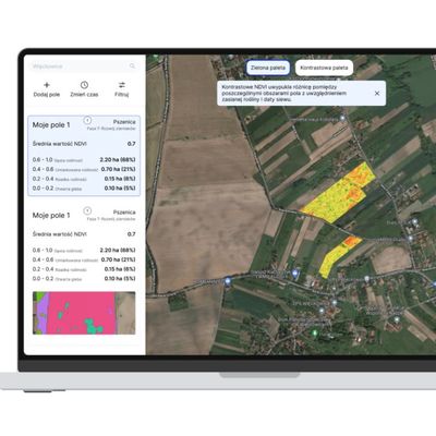
NDVI Maps
Now with MeteoTrack, you will be able to generate maps of your fields with soil productivity zones marked. This is an invaluable tool for analyzing and improving soil quality.
Soil samples
Intelligent soil sampling by grouping soil samples according to the productivity zones of your field
Needs analysis
Precise assessment of areas your fields need additional treatment
Savings
Savings on fertilizer, fuel and manpower through precision fertilization
It allows us to monitor the development of plants, their hydration and potential problems related to nutrient deficiencies.
The NDVI index is particularly useful for farmers, who can use it to optimize their fertilization and irrigation decisions, resulting in better yields.
Its operation is based on the use of infrared wave spectrometry.
This allows us to determine the amount of chlorophyll in a plant, and thus its level of development and health.
Use of satellite imagery
We use high-resolution satellite images of your field with a vegetation difference index (NDVI)
Creating a productivity map
Our algorithms automatically create productivity maps of the field divided into clusters
Support for soil sampling
Productivity map is support for soil sampling and precise fertilization
40%
Savings in fertilizer costs
You can count on such an increase in savings by using NDVI maps
25%
Savings in crop protection costs
By that much, you can increase savings on crop protection costs by quickly detecting diseases and pests, allowing you to take prompt action to prevent their spread
20%
Improving crop quality
By this much you can increase wheat yields compared to conventional crops