
- Home
- Companies
- farmAIr, Inc
- Products
- Our Technology
Our Technology
Early detection of plant stress is a unique AgriTech break through innovation service that only farmAIr can provide. farmAIr technology combines thermal and visual images, machine learning and Artificial Intelligence, in order to reveal Plant Stress, before any symptom is expressed, helping for preemptive measures that will minimize costs. We employ drones, equipped with dual cameras for remote sensing and aerial photography scanning and diagnosis of your field.
Visual Image
We utilize the full potential of high-resolution visual aerial photographs to isolate the plants from the soil.
Thermal Image
We use thermal aerial photographs in order to understand from the leaves’ relative temperature if there is stress.
Image Fusion
Our machine learning algorithms combine visual and thermal images, creating a new set of images of pseudo-color-indicated sub-areas, for every plant having stress (if any).
Artificial Intelligence identifies the problem
Our Object Detection algorithms automatically produce delimited sub-areas of the plant(s) having stress.
Our technology will make you see
Plant stress is not visible to the naked eye in the early stages, but as of today, you are able to know well in advance. Thanks to our pseudo-color image, you are able to clearly indicate the problem well in advance and act, giving you time to act proactively, and conserve considerable costs.
30 days later
The problem which our technology revealed 30 days before, is now evident on the infected plan, since no action had been taken in that case.
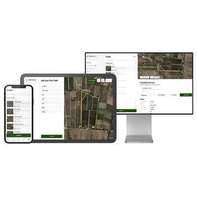
Create your account
You need just one minute to register, so don’t waste time and step into the future, using our technology. Monitor the progress of your crops, and ultimately improve their overall health and efficiency.
Add your Field
Select your field on the satellite map with our easy-to-use drawing tool and provide us with some additional information about your vineyard (more crops are coming soon).
Choose between our End to End or Bring Your Own Images packages.
You can either enjoy the full package, by booking the drone surveying of your field with us, or take over aerial photo shooting yourself, and upload your own images – just contact us beforehand in order to comply with our image spec requirements.
AI processing
Our sophisticated AI algorithms will process the images of your field. It is not magic, it is the new age, cutting edge technology that farmAIr is bringing to you now, saving you time, money and effort.
Check the Results
You can check the results from anywhere. You just need an internet connection. Login to your account and check your report to see if you have any stressed plants in your field. Go back to past reports anytime to identify any patterns. Is that simple!
Navigate to each stressed plant
You have stressed plants that you can’t see with your naked eye? No need to worry! Click on the pins on your field’s report, see the picture and simply walk to the stressed plant. The distance calculator will help you locate the exact position on the map.