

- Home
- Companies
- Risutec Ltd
- Products
- Risutec - Model ASTA-x - Handheld ...
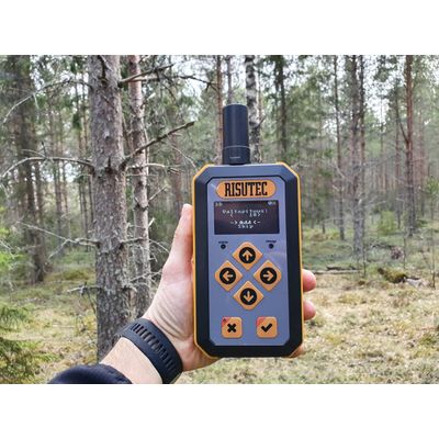
Risutec - Model ASTA-x -Handheld GPS/RTK Forestry Marking and Guiding Solution
ASTA-x is a solution for in-field point location on a grid and data collection in-field. Powered by a rugged GIS GNSS receiver for online and offline operations.
ASTA-x will help you locate the nearest geopoint on a predefined grid with centimeter-level accuracy for planting, pole planting, pitting, mounding, drilling, and other applications that benefit from establishing a defined spacement. It’s the ideal solution for forestry, viticulture, orchards, and more.
Real-time documentation allows you to document results on any numerical variables of interest with precise, georeferenced data points. ASTA-x includes a cloud-hosted service for data retrieval and manipulation as well as powerful APIs that enable real-time integration with any GIS or geographical ERP-system. The solution also facilitates business process re-engineering between contractors and clients, providing more transparency between parties, like moving from hourly or by-area remuneration to spot-based or unit-based billing.
ASTA-x works in online and offline modes. In offline, or GPS-mode, the unit achieves meter accuracy suitable for most data collection tasks in data-entry and growth monitoring applications. In online mode, the ASTA-x uses the cellular network for multi-band RTK to deliver centimeter-level accuracy in seconds. Online mode enables precise in-field operations for drilling, pitting, and especially with the grid functionality applications with rigorous spacement requirements such as fruit tree or foresty planting.
01
You start by assigning the distance between lines in centimeters
04
The operator marks the starting point
02
Assign the spacement between objects (poles, pits, seedlings, etc.) on the line, in centimeters
05
The device is moved to a location indicating the direction of the line at least 10 meters away, and point “B” is marked
03
Move the device to the zero-point position, i.e., the starting point – “A” – that instantiates the line
06
The device always guides you to the nearest point, regardless of whether it is already marked
The ASTA-x service creates a project for the subjects under assessment, such as species or variety, planting depth, growth, diameter, fertilization rate, humidity, temperature – any measurable variable of interest
01
Power-on the handheld device, it connects to the internet automatically
04
The operator assesses the point for variables of interest and validates the location
02
ASTA-x activates the project of interest and is now ready for use (even in Offline mode)
05
Upon work completion, the operator uploads the collected data to the project
03
The handheld device guides the operator to the geopoint (location) under assessment
06
Real-time monitoring of device location is possible as long as the ASTA-x is online
The ASTA-x enables high update rates with highly dynamic applications in mind for centimeter accuracy in a small and energy efficient module. Correction works over the cellular network in 2G and 4G modes, and comes with a robust tripod (7 kg, length 50 cm, breadth 22 x 27 cm).
- Multi-band GNSS receiver
- Multi-band RTK with fast convergence times and reliable performance
- Concurrent reception of GPS, GLONASS, Galileo and BeiDou
One base station can operate/cover many handheld/in-field devices - save compared to traditional GNSS systems.
Overlay in-field results on your preferred map for reporting and research. ASTA-x comes with integration points for any GIS or GEO ERP interface.
The Risutec ASTA is integrated to your excavators joystick. We can preprogram often used operations to different buttons for effective operating.
Contractor and sub-contractor management through the cloud-hosted management console.