

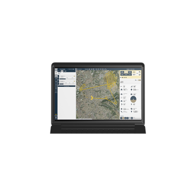
Interaction during drone flight
Modify a flight plan or send commands anytime during a planned mission.
Airspace management
Import geo-awareness maps to have all the restricted and no-fly zones on your flight map.
Notifications and warnings
Audio and color-coded notifications – advisory, caution and critical – before and during flight.
- Flight plan creation
- Autonomous geotagged data capture
- Postflight process (PPK)
- Data ready for post-processing and analyses
Beginner-friendly yet packed with advanced features to tackle the toughest jobs, eMotion simplifies every step of your mapping project, helping to get your eBee in the air quickly, so you can focus on what’s important – analyzing geospatial data.
Draw the area you want to map and eMotion creates the flight plan.
Adjust the mission parameters or select the optimized preset settings for the project type, the camera used, and the terrain.
Horizontal, corridor, point of interest (POI), multiple and custom.
Agriculture, utilities, environmental, surveying, mining, humanitarian, governmental, disaster management, coastal and more.
Flying experience recreation with included RTK/PPK. Possibility to modify parameters to see their effect on the drones.
Just a few minutes are needed to prepare a simple mission, with the possibility to choose optimized presets or custom settings – GSD, overlap, etc.
Drone battery level, home distance, link quality, flight time, altitude, wind, ground and air speed, and more.
Images are automatically geotagged during flight to provide you with a time-saving advantage in post-processing.