

Ceres AI - Crop Inventories Tool
An accurate measure of agricultural lands’ actual crop area is essential to growers and their partners, from insurers to investors—but traditional methods of inventorying crops are labor-intensive and difficult to scale. Ceres’ remote-sensing-based alternative makes it possible to assess and manage global portfolios with ease.
- Distinguishing between productive and non-cropped portions of agricultural land
- Accounting for variability in crop age and plant size
- Comparing crop types and varietals
- Planning for soil health initiatives, habitat protection, and other sustainability measures
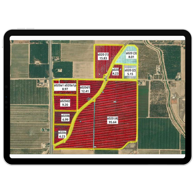
When it comes to agricultural land, maps alone can’t provide the full picture. Within a single orchard, for example, trees of different ages and varietals may produce in different years or months. The presence of irregular field boundaries, surface waterways, erosion, and terracing and other control structures can mean that only a portion of the field acreage includes the target crop.
It can take weeks to reflect this type of variability using measurement wheels or handheld tree counters, and the results are prone to human error. Ceres offers a cost-effective alternative, combining machine learning with high-resolution imagery to generate accurate crop inventories remotely. Detailed assessment of factors such as perennial crop spacing and canopy size mean that our customers can move beyond infrequent and incomplete inventorying to change detection and comprehensive monitoring.
Ground correction and orthogonal controls ensure Ceres’ crop inventories reflect only productive acreage, excluding non-producing land, ground cover, and other unwanted “noise.”
Image capture
We capture imagery during peak daylight hours and under weather conditions that minimize distortion from shadows and cloud cover. Our highly sensitive, custom-built cameras detect minute changes in the multispectral range—allowing us to detect crop stress earlier than our competitors.
Processing and analysis
Imagery is geo-referenced and meticulously “masked” to ensure that only relevant information is evaluated. By making use of crop-specific data models and isolating the canopy from ground cover and other background noise, we prevent skewing of the data and enable a more accurate assessment of plant health.
Quality control
Imagery is assessed in-house by Ceres Imaging’s remote sensing experts, passing through multiple checkpoints before delivery in the Ceres Imaging app within 48 hours of the flight. Growers can access their data on a mobile device, tablet, or desktop computer.