Remsoft
  1. Companies
  2. Remsoft
  3. Software
  4. Remsoft - Version Op Tracker - Forest ...

RemsoftModel Op Tracker - Forest Machine Telematics Solution

SHARE

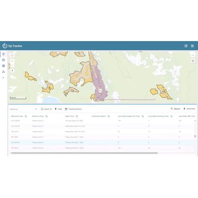
The Op Tracker is a telematics solution catered to the forestry sector, enhancing operational efficiency by integrating machine tracking and data analytics. Built on Esri ArcGIS technology, it enables seamless data integration, providing real-time insights and facilitating field operations. The application supports both online and offline functionality and is compatible with GNSS for offline map and boundary proximity alerts. Its machine and manufacturer-agnostic nature ensures versatility across various operational setups. Featuring GPS tracking, automated reporting, and machine-to-machine connectivity, it helps optimize operations, reducing fuel consumption and cost while offering comprehensive operational insights. Ideal for contractors and forestry product companies, it ensures data accuracy and operational efficiency across mixed machine fleets, supporting satellite communication in remote environments for uninterrupted data flow.

Most popular related searches

Streamlines operations, cut costs, and deliver real-time insights with seamless data integration and advanced field functionality

Op Tracker enhances operational efficiency and reduces costs by automating data transfer and leveraging GIS data for real-time machine tracking and analysis. This versatile, machine-agnostic solution provides up-to-date information through seamless web and mobile app syncing, offering comprehensive operational insights and robust field functionality with offline access and proximity alerts.
Increased Efficiency

Reduces the need for weekly drive time by automating data transfer, saving significant time and resources.

Cost Reduction

Pays for itself within months by decreasing operational costs, especially as fuel prices rise.

Real-Time Data Access

Provides up-to-date information through automatic syncing between web and mobile apps, ensuring everyone works from the same current data source.

Comprehensive Operational Insights

Streamline and schedule forestry activities with intuitive, easy-to-use tools.

In-Field Alerting & Warning

The Op Tracker mobile app, compatible with GNSS, provides offline map access and boundary proximity alerts for users in the field, enhancing operational accuracy and efficiency.

Machine- and Manufacturer-Agnostic

Works with any machine, making it a versatile solution adaptable to various operational needs allowing for “apples-to-apples” data comparisons.

GPS Tracking and Alerting

  • Track the location of your machines.
  • Remain compliant, by alerting machine operators before they go somewhere they shouldn’t.
  • Auto start tracking when block entered to avoid data gaps.

PMH, Utilization and Productivity

  • Calculate productive machine hours (PMH).
  • Calculate utilization of each machine and fleet-wide.
  • Calculate productivity of machines (m3/hr).

Online and Offline Capable

  • Works in offline/disconnected mode when there is no internet and sync when back online.
  • Use imagery and lidar raster products as backdrops on the map.
  • Auto-sync based on a user-configured schedule.

Integrates by Default with the ArcGIS System

  • Leverage your ArcGIS Online or ArcGIS Enterprise GIS services.
  • Works seamlessly in tandem with other Esri mobile apps, such as ArcGIS Dashboard, Field Maps and Survey123.
  • Supports complex map symbology so no need to change your existing maps.

Activity Codes, Stop Codes and KPIs

  • Prompt operators for activity codes so you always know what’s going on in the field.
  • Show KPIs to operator for performance management.

Automated Reporting and Analysis

  • Op Tracker crunches the data at end of shift so anomalies, such as abnormal fuel consumption, can be identified.
  • Automatically send summary reports by email.
  • Compatible with ArcGIS Dashboards and PowerBI for user-configured reporting.
  • Trigger automation rules and business processes in the cloud or on-prem.

Real-time Data and Connectivity

  • Choose satellite communication option for machines that work in remote environments and rarely in cellular communication range.
  • Optional machine-to-machine (M2M) capability so every working machine is aware of its peers.

Benefits for forest products companies and forest management consultants

Minimize Fuel Consumption

Minimize fuel consumption and reduce your company’s carbon footprint.

Optimize Operations

Optimize operations and save costs through actionable insights gained from Op Tracker data analytics.

Always Know What’s Happening with Your Operations
Decrease administrative efforts by consolidating your GIS, progress, and productivity data into one solution that updates automatically in near-real time.