

CyberSWIFT
- Home
- Companies
- CyberSWIFT
- Software
- CyberSWIFT - Version LAMS - Land ...
CyberSWIFT - Version LAMS -Land Acquisition & Management Software
FromCyberSWIFT
Dedicated Land Management software that manages all land acquisition related activities and consolidates all land-related data into a single system to manage and monitor all your land assets.
Most popular related searches
LAMS is a web and mobile-based business solution that acts as a central repository of all Land related data & documents, making it accessible anytime anywhere.
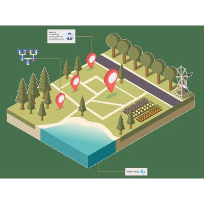
- Plot Map Visualisation
- Land Acquisition Process Monitoring
- Owner & Family Tree Analysis
- Plot & Asset Valuation
- Encroachment Detection
- Legal & Litigation Tracking
Data Analytics
- Track Land Acquisition Stages as per state wise LARR Act with Gnatt Chart, Timeline tracker, Responsible person monitoring.
- Monitoring of disputes, encumbrances, court cases, advocates, and other legal matters.
- Ownership management of plots with tracking & updating of Plots owner, family tree, and stakeholders.
- Macro to Micro-level monitoring of resettlement, compensation & payments.
- Alerts on deed renewals, upcoming hearings, pending approvals, etc.
- A central repository of all documents against each plot.
- Plot value estimation consideration the assets with auto calculation of taxes & duties.
- The payment calculation module can be integrated with existing ERP Payment Modules or Accounting systems.
- Customized Dashboard and Reports downloadable in Excel or CSV formats
Location Analytics
- Mapping & Management of multilocational land across units.
- Visualise plot-wise map with Administrative boundaries, Waterbody, Habitation, Road & Railway, etc.
- Thematic color coded maps based on land type, acquisition status etc.
- Digitised map of resettlement colony with occupied status of PAF details.
- Satellite images/ Google/ Bing Map integrated on a background as base imagery.
- Change & Encroachment detection using topographical feature extraction of satellite imagery.
- Offline Mobile app for data capture in areas with no network connectivity.