Remsoft
  1. Companies
  2. Remsoft
  3. Software
  4. Remsoft - Version AFRIDS - Lidar Forest ...

RemsoftModel AFRIDS - Lidar Forest Inventory Mapping & Analysis Tool

SHARE
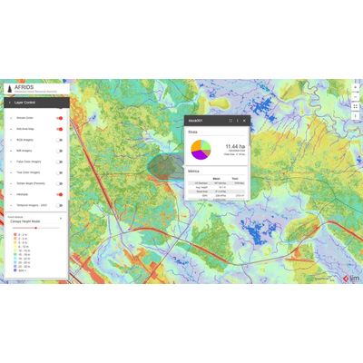
The AFRIDS platform from Remsoft is a comprehensive web-based decision support tool designed for lidar forest inventories. Embedded within the platform is Esri ArcGIS technology, enabling advanced mapping, data analysis, and reporting capabilities that require no specialized GIS expertise. This tool aims at optimizing forest operations by providing features such as dynamic block calculations and cost planning for accurate route optimization. AFRIDS integrates seamlessly with other Forest Management Systems or enterprise solutions. Its cloud-based infrastructure ensures secure, versatile access from any location, eliminating the need for in-house IT support. Since its inception in 2011, AFRIDS has supported over 30 million hectares globally, providing invaluable insights and efficiency in forest metrics estimation, including volume and basal area. Furthermore, the Temporal Imagery tool allows users to track inventory changes over time, enhancing the strategic management of forestry resources.
Most popular related searches

AFRIDS is web-based decision support tool, built on Esri ArcGIS, that offers advanced mapping, data analysis, and reporting tools for lidar forest inventories.  Optional extensions are available for cost planning and route optimization, all accessible anywhere and requiring no GIS expertise.

Forest-wide Inventory

Utilize the power of remote sensing, forest biometrics and artificial intelligence for wall-to-wall forest inventory predictions.
Better Planning

Quickly estimate important forest metrics, like volume and basal area, for a planned harvest, disturbance, or custom area.

Powerful Tools

Simplify your workflow with user friendly dashboards, powerful reporting, and easily integrated Esri services.

Access Anywhere

Forget the hassle of in-house IT with a secure solution that runs on industry-leading cloud technology.

Block Calculations

  • Use existing blocks to automatically roll-up EFI statistics.
  • Calculate average and total metrics for multiple blocks in seconds.

Dynamic Block Calculations

  • Draw a polygon block to automatically roll-up EFI statistics.
  • Display diameter size class distribution with a block.
  • Display piece size distribution within a block.

Easily integrates with other FMS or enterprise systems

  • Integrate with your FMS or enterprise systems.
  • Integrated with non-Forest365 FMS via REST API.
  • AFRIDS can be deployed directly in Status to leverage EFI in for planning and monitoring.

Route Analyst

  • Pick a starting point and destination, and calculate the best route based on time or distance.
  • See the cost of the route.
  • Adjust cost factors to see changes to route cost.
  • Leverage the route analyst tool to review and fix disconnected/broken road networks.
  • Add barriers to simulate road closers or non-suitable roads and recalculate the optimal route in seconds.

Cost Planning

  • Build scenarios by allocating blocks to mills or other destinations.
  • Adjust cost variables to see impact on scenarios.
  • Adjust forest variables, such as seasonality, to see impact on scenarios.

Import, Export and Print

  • Import and export Shapefiles.
  • Import and export CSV files.
  • Print digital maps based on map templates.
Optimized Resource Allocation
Leverage your EFI data into tactical scheduling, machine allocation, and mill assignments to ensure the right wood reaches the right place at the right time.
Efficiency and Simplicity
Save time and streamline your workflow with repeatable and automated processes, reports that load in seconds, and user-friendly dashboards.
Versatile Applications
Utilize AFRIDS for a range of additional purposes, including stream crossing management, habitat management, and right-of-way planning.