Katam Technologies AB
- Home
- Companies
- Katam Technologies AB
- Software
- Katam TreeMap - Precise Route Planning ...

Katam TreeMap - Precise Route Planning Tool
Optimise instructions for thinning strength and route planning in advance with more precise data. With Katam, you are always prepared to adapt to local variations in the total stand.
Most popular related searches
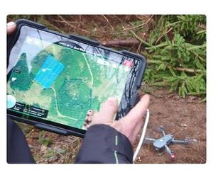
- Configure drone flight route on your mobile device. Connect to drone and press FLY-button.
- After flight mission, upload drone images to KATAM™ TreeMap web portal.
- After processing the measurement result is presented directly in the web portal. Download high resolution orthophoto, GIS analysis and PDF reports. Or connect directly to a geo-server.
- Get up-to-date maps directly to your operator monitor. Supported by John Deere, Eco Log and more.
- Download maps to your mobile phone.
- Export forest data directly to your forest management system.