


Rezatec - Geospatial AI for forest inventory
Zero in on the value: Our forest inventory product uses geospatial AI to remotely analyse inventory across your entire forest. To individual tree level. Without the need for aerial surveys. It provides detailed, continuous data on height, count, volume and species distribution as it changes over time. Use this frequently refreshed information to cost-effectively determine harvesting potential, forecast supply, assess stock values and optimise operational work. And gain advantage when competing for harvest rights.
Monetise the right timber at the right time
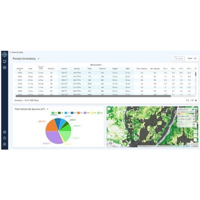
View your entire inventory
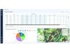
Remotely assess species distribution, density and volume, without the need for costly aerial and ground surveys.
Target the right timber
Accurately forecast supply and select the right species, grade and length for your mills.
Boost mill throughput
Optimise supply and boost the flow of monetizable inventory by extracting and transporting the right lumber to the right mill at the right time.
In commercial forestry, performance is driven by the forested area’s harvestable yield. It’s critical to deliver the most value from every acre and ensure its long-term viability. Having visibility of spatial species distribution, abundance and density is a critical part of this especially when the species composition is mixed.
In large managed forests, it has often been challenging to cost-effectively obtain up-to-date, accurate data on available timber volumes. Why? Because traditional ground and aerial surveys require a big investment – they happen infrequently and therefore information is often out of date.
Our forest inventory product uses satellite and multiple data feeds fused with advanced AI to remotely analyse inventory. It continuously maps huge geographic areas and drills down to individual tree level. Its highly detailed and accurate insights remove the need for aerial surveys. It provides regularly refreshed data on the height, count, volume and species distribution of the forest’s inventory as it changes over time. Forestry leaders use this information to cost-effectively determine harvesting potential, forecast supply, assess stock values and optimise operational work. In addition, it puts them at an advantage when competing for harvest rights.
All data can be integrated into existing GIS systems, or delivered through our Forest SAT solution on the Rezatec platform.