

RoboWeedMaps Software
The perfect platform for finding, mapping, interpreting and understanding your weed distributions. Fast processing of images and weed recognition in images resulting in maps for individual fields. Giving a quick and intuitive workflow allowing for fast, and data driven decision-making. Your platform to gain insights into your individual fields weed population to make tailored herbicide treatment plans.
RoboWeedMaps is our solution for consultants and farmers for their optimization of herbicide applications.
This software analyses images from individual fields and recognizes monocotyledon and dicotyledon weeds and reveals distribution pattern. Based on this, data spraying maps tailored to individual fields can be provided which allow for the reduction of herbicides applications based on individually chosen thresholds.
Besides saving money, this approach will increase the sustainability of agriculture and as the data can be saved it also allows for documentation.
Our software solution gives you unique insights into individual fields and allows for data based decisions for optimal herbicide treatment results. Saving you money, time and herbicides.
Automated weed detection
Save up to 80% of herbicide use by generating spot-spray maps for your fields. Just treating what needs treatment.
Farming face challenges in the choice of doses and active ingredients of pesticides due to limited knowledge on distribution and type of weed species in the field.
Precision weed management can decrease herbicide application without sacrificing yield. In the RoboWeedMaps system this is done by combining Deep Learning and Big Data.
By the reduction of the amount of herbicide used and their correct choice it is estimated that savings made as a result of the project will be in the range of 40% (for standard farming practices) and up to >80% (for emerging high-tech farmers that use the new generation of injection sprayers).
How is it done?
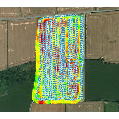
RoboWeedMaps is a service tool for image analysis. To acquire images a consultant drives over a field with an ATV, taking pictures every 5 meters. These images are uploaded to RoboWeedMaps, annotated (automatic finding of weed plants) and classified (evaluation "who" is there).
Based on the results of the images analysis, maps of the monocotyledons, dicotyledons and important weed species are generated. Thereafter, a spraying map is provided to the farmer with different pesticide treatment options to choose from.
By combining different pesticides and doses the weed is treated in the most case specific way possible and leads ideally to the reduction of cost and amount of pesticide sprayed, helping the farmer to fulfill the regulations of pesticide usage.
Curious about how many images have been analyzed with RWM, how many weeds have we found and in how many fields did we map the weeds? Have a look!
54
Avg. # weeds/image
1117
# fields mapped
2006049
# images
115854723
Nr. found weeds