

AgroMonitoring
- Home
- Companies
- AgroMonitoring
- Software
- AgroMonitoring - Version Agro API - ...
AgroMonitoring - Version Agro API -Satellite and Weather Data Software for Precision Farming
FromAgroMonitoring
Through our simple and fast API, you can easily implement multi-spectrum satellite imagery, vegetation indices and weather data of the crop for the most recent day or for a day in the past to your projects.
Most popular related searches
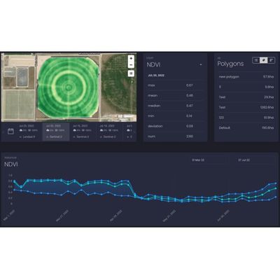
SATELLITE IMAGERY
- New satellite imagery every 2-4 days
- NDVI, EVI, EVI2, NRI, DSWI, NDWI indices for any polygon
- Historical archive of satellite imagery from
- Satellite imagery data from Landsat 8 and Sentinel-2
- On-the-fly processing
SATELLITE DATA
- Numerical values of NDVI, EVI, EVI2, NRI, DSWI, NDWI indices statistics for every field
- Historical NDVI data for a polygon
- Accumulated temperature and precipitation
- Soil temperature and moisture on the different depth
WEATHER DATA
- Current weather for any geographic coordinates
- Forecast for 5 days ahead with 3- hour step
- Historical weather archive with depth by request
- Data sets include air temperature, humidity, wind speed and other significant weather parameters.