

SoftWright - 3D Display Module
Turn your engineering design excellence into powerful presentations. Real world coverage is shown in the real world. Your radio coverage area is not flat. Better visualize your radio coverage challenges. You know where you have coverage problems. Show others why. Intuitively communicate how terrain helps or hurts your coverage area. Help your customers visualize real coverage problems. Show zoning boards why a particular transmitter site is superior or inferior to others. Show your advertisers how well you really cover the market.
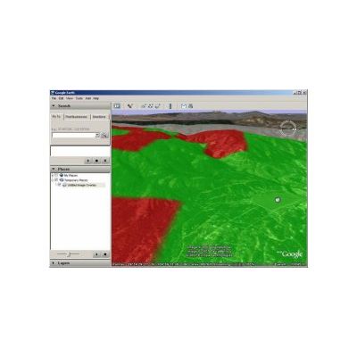
The 3D Path Export utility is accessible from the TAP path analysis tool. The result, an example of which is shown above, includes a red (by default) line of sight with a blue 3D Fresnel zone mesh. This is particularly useful when looking for Fresnel obstructions along the sides of an RF path in urban or forested areas.
From TAP Mapper, there are three options for 3D Export:
- View in 3D KML Viewer: Exports the current map view (excluding the basemap) as a georeferenced graphic and associated .kml file. Launches the installed default .kml viewer. It is recommended that the map shapefile layers be fully opaque when using this technique so that the opacity may be set more easily in the 3D viewer. Advantages are that the export is fast, the file sizes are small, and the entire map view is exported in one click. One .png and one .kml file are created and need to be used together when shared. Disadvantage is that some pixilation may occur at certain zoom levels due to limits in resolution of the .png file.
- View Layer in 3D: Exports the currently selected shapefile layer directly as shape information in a single .kml file and launches the default .kml viewer. Pay close attention to the selected shapefile – the associated tile in the layer list will have a purple highlighted border. Advantages are that the 3D export will look great at all angles and zoom levels and only a single .kml file is created. Disadvantages are that only the selected layer is included, it takes longer to write the .kml file, and the file sizes can get very large. For example, in one benchmark test of a coverage shapefile with 250,000 shapes, the resulting .kml file was approximately 100 MB.
- View 3D Zip: Same behavior as View Layer in 3D except the output is written to a .kmz file (a zipped/compressed .kml file). This makes it easier to share the resulting file.
In addition to providing export of kml/kmz files, TAP Mapper also features a built-in 3D viewer. Simply click on the 3D tab and the current map view will be shown in 3D.
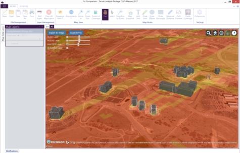
Mapper 3D View with 3D Buildings
If Mapper is currently in Path Preview mode then the 3D path preview is shown. Otherwise, the current 2D map view is shown as a 3D overlay. Add land cover (NLCD or MODIS) using the check boxes and use the buttons to export the 3D image for use in a document or report or to load a 3D kml or czml file. For instructions on how to control the 3D view, click on the ‘?’ button in the upper right.