

- Home
- Companies
- SoftWright LLC
- Software
SoftWright LLC software
TAP Modules - Propagation Modules
SoftWright - Longley-Rice (aka ITM) Propagation Module
The Longley Rice (aka Irregular Terrain Model) Propagation module is the most flexible and popular TAP™ propagation module. It is valid for a wide frequency range from approximately 30 MHz to 30 GHz. The Longley-Rice model is an implementation of many of the equations presented in the NTIA Tech Note 101. In addition to expected parameters such as frequency, effective radiated power (ERP), antenna pattern and antenna heights a number of other parameters unique to Longley-Rice are employed. These include such things as climate and soil conditions, ground conductivity and dielectric constant.
TAP Modules - Additional Visualization and Analysis Modules
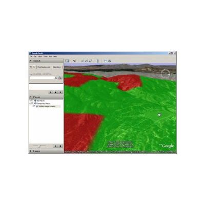
SoftWright - 3D Display Module
Turn your engineering design excellence into powerful presentations. Real world coverage is shown in the real world. Your radio coverage area is not flat. Better visualize your radio coverage challenges. You know where you have coverage problems. Show others why. Intuitively communicate how terrain helps or hurts your coverage area. Help your customers visualize real coverage problems. Show zoning boards why a particular transmitter site is superior or inferior to others. Show your advertisers how well you really cover the market.
TAP Software
SoftWright - Basic Mapping Module
The Basic Mapping Module is the foundation module of the Terrain Analysis Package (TAP). This module provides access to topographic data files of many common formats, including Digital Elevation Models (DEMs) derived from USGS 3-second, NGDC 30-second data, USGS 30 meter data and the newer NED 1-second, 1/3-second, and 1/9 second data, as well as Defense Mapping Agency (DMA) Digital Terrain Elevation Data (DTED) files with 3-second, 30-second and 1-second resolutions. The SRTM (Space Shuttle) data files are also supported throughout the world.
Others
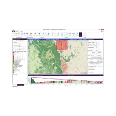
TAP Mapper - RF Analysis and Visualization Software
TAP™ Mapper is an RF analysis and visualization software tool available as a standalone subscription product as well as for use alongside the full TAP™ RF engineering software. TAP™ Mapper is a Windows desktop application that accesses global terrain and land cover data via the internet in order to facilitate RF engineering tasks. It provides ultra fast loading, rendering, and styling of shapefiles.