

Pear Technology Services Ltd.
PearGIS - Desktop Based GIS Package
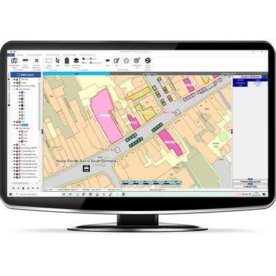
PearGIS is a powerful desktop based GIS package that offers simple mapping functionality with database driven decisions.
Most popular related searches
- Simple drawing tools for lines, points and areas
- Add a wealth of database information to your map
- Find information quickly by searching your data
- Intuitive, easy to use interface
- Link in external databases from your network or third party software
- Stream in data from the web (e.g. Natural England, Environment Agency etc.)
EASY TO USE
- New and improved drawing and measuring tools
- Select fields to see your information (crop, field name, area etc)
- Import RPA Field Boundaries and add field margins for CSS
- Easy to use ‘snap to line’ feature
- Clear, modern interface helps explain the functionality of each feature
DATABASE VIEW & REPORTING
- Add data to your map layers and view this alongside your map
- Search for features to easily find them on the map
- Filter your data to find the information you need
- Export your data to Excel to do carry out futher analysis
GOOGLE EARTH
- Open your layers in Google Earth to analyse them against aerial imagery
- Trace around features in Google Earth and copy these back to your PearGIS map
- Use the Google Earth timeline to view historical imagery
FILTER STYLE
- Style your map using the data you have inputted i.e. by Forestry Species (see image)
- Filter styles are neatly managed within one layer on the layer list
- The map style automatically responds to any changes made in the database
STREAM GOV. DATASETS
- Stream layers into your map from websites such as Env. Agency, Natural England, British Geological Survey and more
- Data from the web is kept live and current on your maps
- Identify if your land is effected by any nearby environmental factors
EXTERNAL DATA
- Link your map to external data sources such as Excel, Access, SQL and more.
- Seamless link with Landmark’s KeyPrime (Property Management Software)
- Save on duplication by bringing in cropping data, ownership information, property data etc.