

- Home
- Companies
- Katam Technologies AB
- Software
- Katam - Version TreeMap - Drone ...
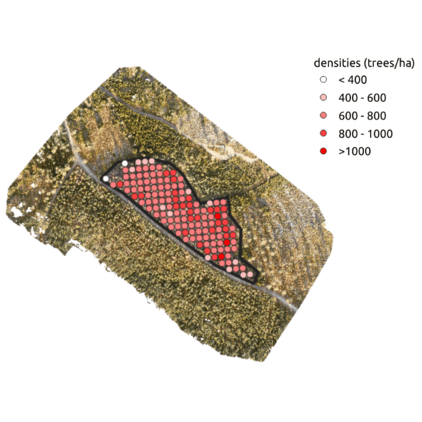
Katam - Model TreeMap - Drone Measurement for Improved Thinning
Achieve optimal thinning for each part of the stand. Katam TreeMap shows the variations within a forest stand with distribution of stem density and tree height over all parts of the stand. The information provides a valuable basis for decision-making that enables optimal withdrawal as well as increased volume and yield in the long run.
Species and height is registered for each single tree. Also health status can be detected, e.g. dead trees due to spruce bark beetle attack (see picture). Trees that should saved for natural conservation reasons can be identified.
The system identifies existing network of previous thinning paths. Can be combined with topographic map and soil moisture map.
Fast and easy accessGet feedback on the ongoing thinning work directly in the field. Within a few hours after the drone recordings have been uploaded, KATAM TreeMap will deliver an analysis of the entire stand. The report can be directly exported to different types of forestry systems.
Get volume information for each single tree by matching drone measurements from air with smartphone measurements from ground, using the Katam smartphone app. Provides a complete high-resolution stem inventory.
Make comparisonsMake comparisons of the forest stand before and after thinning, both in terms of quality and quantity.
Configure drone flight route on your mobile device. Connect to drone and press FLY-button.
After flight mission, upload drone images to KATAM TreeMap web portal.
After processing the measurement result is presented directly in the web portal. Download high resolution orthophoto, GIS analysis and PDF reports. Or connect directly to a geo-server.
Get up-to-date maps directly to your operator monitor. Supported by John Deere, Eco Log and more.
Download maps to your mobile phone.
Export forest data directly to your forest management system.