Forest Road Articles & Analysis
5 articles found
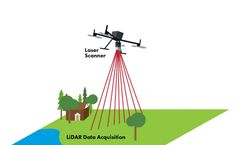
Therefore, Inertial Labs has created a product that will solve many problems related to forest monitoring. Some of these solutions include: By flying over a forest while using LiDAR, users can get a map of elevations and terrain to properly plan road construction, manage tree cutting/planting, and analyze fire risks [10]. ...
At a recent exercise in Idaho, we discovered that the forest service access roads in many regions are marked on the ground using number identifiers even when a road name exists. Remote forests in the US are often navigable only by a maze of numbered utility roads and our map’s users need more information to ...
ByAzimuth1
Optimizing landfill life by choosing the most efficient landfill compactor is giving Forest Road landfill more operation years. "Waste density in completed cells will now be increased from approximately 800 kg/cubic meter to 1200-1400 kg/cubic meter under standard operating conditions", says Jon Beckett, Waste Services Manager. ...
ByTana Oy
Rehabilitation and reforestation of disused forest roads and landings can be facilitated by the incorporation of organic matter. The British Columbia forest industry creates residual woody materials, but they are nutrient poor and may leach phenolic compounds. ...
In order to understand the urban forest structure and its function in environmental improvement 5 major landscape elements, i.e., building and hard pavement surface, water, road, urban forest, and general green land in the area (Brazel et al., 2000, Wu et al., 2003) must be considered. Hence, larger pieces (1.5-3.0 hm2) of urban ...


