

TerraSphere Imaging & GIS B.V. services
Actionable Data Services for Farmers
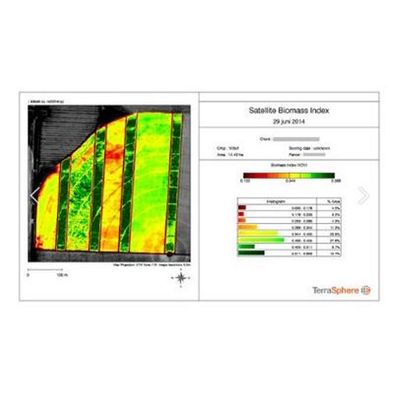
TerraSphere converts satellite imagery into actionable data. In the Netherlands, we process all satellite data for the Fieldscout App, winner of the Dutch Galileo Masters and Dutch Interactive Award. The service includes task maps for variable rate application of fertilizer, potato haulm killing, and scouting maps to analyse growth anomalies in the field. The service is also available through farm management systems at Akkerweb & DACOM.
Decision Support Services
In Bangladesh and India we run the award-winning GEOPOTATO service together with Mpower and Bayer. 40,000 smallholder potato farmers signed up to receive SMS alerts on when, what and how much to spray against Late blight disease. Satellite data is used to monitor Leaf Area Index as input in the Decision Support Service that calculates infection risk based on a model developed by Wageningen University. Farmers have decreased crop losses by more than 30% through GEOPOTATO.
Agribusiness intelligence Services
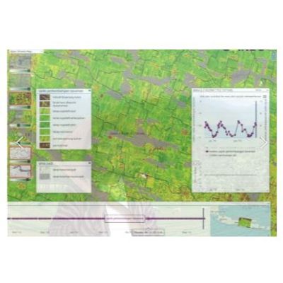
TerraSphere provides mapping of crop parameters like crop extent, crop type, biomass development and yield over large areas. In Myanmar TerraSphere produces satellite-based intelligence for Village Link who run the Htwet Toe app and VLSS platform connecting farmers with agronomists and agribusinesses. In various African countries, starting in Kenia, Tanzania and Uganda, we map crop type and extent for GEOGLAM. The data is used to forecast production and monitor food insecurity.
Micro-credit Parameter Services
Satellite data can be used to monitor crop development of individual fields throughout the entire growing season. The system is currently being deployed in with AWBA in Myanmar. By comparing fields, relative performance can be calculated against regional and multi-year averages. This information can be used as input into credit-scoring engines of micro-credit providers to assess and decrease loan default risk of farmers.
Crop Insurance Support
Satellite data is used for automated claim checking and risk assessment for crop insurance in Indonesia, through a platform build for Indonesian insurance company Jasindo. We analyse crop growth, detect anomalies and assess damages resulting from floods, drought and diseases. Cost savings on field checks are achieved with 1 million smallholder farmers insured. TerraSphere also partnered with HARA to integrate satellite data analytics in their App serving smallholder farmers in Indonesia.